- YourGovernment
-
OurCommunity
-
- About Tualatin Advisory Committees Animal Services Community Involvement City Codes City Council City Projects
- Community Crime Reports Customer Service Request Explore Tualatin Now Fire Library Municipal Court Tualatin Today
- Parks & Recreation Passports Permits & Forms Planning & Zoning Police Volunteer Tualatin Moving Forward
-
-
ForVisitors
-
- Parks, Greenways, Recreation and Library Library Parks Public Art Parks and Recreation
- Shopping, Dining, and Entertainment Chamber of Commerce
- Community Events Community Theatre Pumpkin Regatta Special Events
-
- DoingBusiness
-
HowDo I?
-
- Apply for a Job Apply for an Advisory Committee Contact the City Council Get a Copy of a Police Report File a Records Request Find Forms
- Find Planning & Zoning Find Public Transportation Find the City Code Get a Business License Get Email Subscriptions/Notifications Locate City Offices
- Contact the City Pay My Traffic Fine Pay My Water Bill Reserve a Facility Sign Up for a Recreation Program Search the Website Volunteer
-
Basalt Creek Map Amendment (CN and RML) (PTA 20-0005 and PMA 20-0002)
Project ID:
PTA 20-0005 and PMA 20-0002
Applicant Information:
AKS Engineering
Reviewing Staff:
Steve Koper
Tabitha Boschetti
Project Staff Contact:
Tabitha Boschetti
Project Type:
Land Use
Plan Map Amendment (PMA)
Plan Text Amendment (PTA)
Location:
23620 SW Boones Ferry Rd et. al.
Tualatin,
OR
97062
See map: Google Maps
Tax Map/Lot:
2S135DO0401
2S135DO0400
2S135DO0500
2S135DO0501
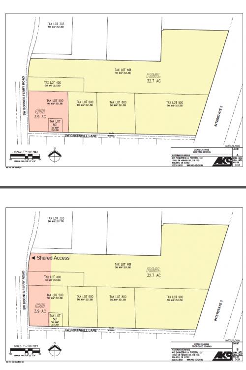
AKS Engineering, on behalf of Lennar Northwest, Inc., has submitted an application to reconfigure zoning boundaries between the Neighborhood Commercial (CN) and Medium Low Density Residential (RML) land use designations/zones at an area east of SW Boones Ferry Road, north of SW Greenhill Lane, involving parcels at Tax Map 2S135D, Lots 400, 401, 500, and 501. Under this proposal, the net area of each zone would stay consistent, but rather than forming a rough square at the intersection of Greenhill and Boones Ferry with additional residential zoning to the north, the commercial zone would occupy a more elongated rectangle fronting on SW Boones Ferry, with residential areas at a more distant remove from the arterial.
This proposal was adopted by Tualatin City Council through Ordinance No. 1454-21 on March 22, 2021.
The proposal will be discussed at the Tualatin Planning Commission meeting on February 18, 2021, with the meeting packet to be published one week prior and available at https://www.tualatinoregon.gov/tpc/tualatin-planning-commission-18.
A hearing has been scheduled before Tualatin City Council for March 8, 2021. The meeting packet for the City Council meeting will be published one week prior to the hearing and available at: https://www.tualatinoregon.gov/citycouncil/city-council-meeting-339.
Files: Ordinance No. 1454-21 (19 MB) Application for Map Amendment (922 KB)